Saturday, October 23, 2010

Tramping through the Woods in Nova Scotia and Other Highlights

Everywhere we go in Nova Scotia the scenery is stunning, especially now with a full spectrum of fall colors plastering the forests and hills and lining rivers and lakes. There are also large stretches of pastureland and farmland with picture-perfect grey and red barns, appropriately aged. 
The marshes along the shore are equally picturesque. Usually we’re in the truck whizzing by all these photo-worthy scenes. It is a feast for the eyes. When the weather is conducive, we try to go on a hike. 
One day we wanted to see a tidal bore. This happens on a river that drains into a body of water that has exceptionally high tides, in this case, the Bay of Fundy. Twice daily, the tidal water is pushed into a narrower and narrower opening until it forms a wave that rushes and gushes up the river, against the normal flow of the river.  On this day it was at noon. By the time we left the campground, it was 10:30, so we had just enough time to squeeze in a quick hike.
We drove about 20 minutes to “the dirt road with ATV tracks before you get to the motel” as explained by the campground owner. “It’s only a short walk to a waterfall,” she said. We found the unnamed “road”, parked, walked a little ways into the woods and encountered a river bridged by a precarious assortment of boards, logs and twigs. “That’s it,” said David, “let’s go back.” “Not yet,” I said and proceeded to try crossing it. David waited for me to fall in. When I didn’t, he followed. We walked a few minutes without finding the waterfall. “We’re out of time,” said David. “It’s 11:30.” 
So we turned around and raced back in time to see the tidal bore, which was pretty interesting, considering one minute you’re looking at a mud flat and a couple minutes later it’s flooded. 
Then we drove to another location to hike the “Rogart Mountain” trail. The trail followed a bubbling brook through a forest of maple trees, whose leaves had turned lime green, yellow and orange providing a striking backdrop for the dark green ferns carpeting the forest floor. Then we started to climb and climb. 
We climbed up to 1125 feet where the maple trees were stunted. In the distance we could see the ocean and windmills on a crest. Then we descended. Suddenly and unexpectedly we came upon a delightful waterfall called “Jane’s Falls.” 
Unfortunately, about an hour into the hike, David’s knee “popped”, and he almost passed out from the pain. His leg had been hurting him all week, and he thinks maybe something popped back into place or maybe it was a pulled muscle. At any rate, the last hour and a half of the 4-mile hike was painful for him. He’s doing better and thinks the problem has to do with all the driving we’ve been doing, but we won’t be hiking any trails with the word “mountain” in them for awhile.  
We’ve done other things besides driving and hiking, especially on rainy days. The rain usually doesn’t stay around long, or as David puts it, “It doesn’t rain here. It antagonistically sprinkles.” Here are a few highlights:
Alexander Graham Bell National Historic Site - Bell made a lot of money with his telephone invention. He used the money to fund other endeavors, including a hydrofoil boat that was the fastest boat in the world in 1919. He had a summer home in Nova Scotia. We spent several hours learning about his life and work in this fascinating museum.
Glennora Distillery - Me: “David, do you want to go on a scenic drive and visit a provincial park or go on a tour of a distillery?” 
David: “Uh, I vote for the distillery.” Actually, it was a scenic drive on the way to the distillery. The single malt whisky distillery, the only one in North America, isn’t much to look at, just a couple rooms with some copper pot stills, but the tour was great, thanks to the tour guide who had the knack of being both informative and interesting. We tasted their 10-year-old $80 variety. (They don’t offer tastes of their 20-year-old $350 variety.) Me: “How do you like it?” David: “It’s good!”
Miners’ Museum in Cape Breton - until the 1960’s, coal mining was big industry in Cape Breton. The museum was good but more interesting was having a retired miner take us down into a 4-foot-high coal mine where he told us about mining first-hand as we hunched over. The walls were black as coal. Actually, they were coal!
Fortress of Louisburg National Historic Site - this was the site of a French fortified town in the 1700’s that had been in ruins until the Canadian government decided to put out-of-work coal miners to work reconstructing it. It’s massive but still only a small part of the original town. During the summer, costumed interpreters recreate life in the 1800’s. When we were there, it was more like a ghost town with only a few hardy (shivering) tourists wandering about. Even still, it was evocative and intriguing, and park employees were around to answer questions. 

Tuesday, October 19, 2010

Fickle Weather and the Dancing Boy

I was disappointed that we hadn’t heard any traditional music yet, so when we got to our campground in Cheticamp, and I heard that a fiddler was playing at a local restaurant that evening, I was thrilled. “Shall I make a reservation for you?” asked the campground manager. “Yes,” I said enthusiastically. He made it for 6.
After we set up the trailer and had lunch, we immediately headed to the Cape Breton Highlands National Park Visitor’s Center. I didn’t want to waste any sunshine. I asked the ranger to recommend the best hikes. She said Skyline was the most popular trail. She said it would take about two hours, and we would see spectacular views of the ocean as well as whales and moose. “I’m so glad it’s sunny,” I said. “And tomorrow will be sunny too!” She looked at me surprised and said, “The forecast is for rain tomorrow!” I didn’t believe her. She showed me her printout. There it was in black and white. We had time to go on the hike, which was about 20 minutes away, before our dinner reservation. 
When we got there, there were quite a few cars in the parking area. In fact, other than Green Gables, this park was the first place we encountered a fair number of people, although it wasn’t really crowded. The sun was shining, but it was very cold. I donned earmuffs, hat, mittens, gloves and coat. D was less equipped. We started walking. There were a lot of dead trees. Evidently, budworm had killed them, and the moose are eating the young saplings, so the forest is still trying to recover. 
After about an hour of walking, we came to a boardwalk that descended a long way down the side of the mountain. You could see the winding road on the mountain, the steep cliffs and a majestic sweep of the  ocean. We didn’t see whales or any moose, but it was worth it. 
By the time we finished the 4.7 mile hike, it was 5:30, so we headed directly to the restaurant. From the outside it looked pretty small--a box painted bright yellow. Inside it was still pretty small but big enough to hold 30 or so people. It was crowded, but we had a small table right up front. The musicians arrived around 6:30. One played the violin and stomped his legs. His accompaniment played the piano. They played traditional Cape Breton music, which is an amalgam of Irish, Gaelic and Acadian. We enjoyed it immensely. Then, about 7:15, almost everyone left to go to a nearby concert. “I forgot there was a concert tonight,” said Mike, the fiddler. “I would have come another day.” We were glad he hadn’t. 
A little while later a family arrived--parents, grandparents and two young boys. There was a little buzz. “It’s Christopher,” said Mike. “He’s an amazing dancer.” And sure enough, after Mike played a couple more songs, 9-year-old Christopher got up, stood in front of Mike and started step dancing while the musicians played. Then he sat down and ate his dinner. A little while later, after he had finished eating, he got up and danced to another song. Awesome. 
The next day, even though I had trusted the weather forecast and had rearranged our schedule so we could be in the park when it was sunny, it rained. 
The park is part of a 185-mile scenic loop in Cape Breton called the Cabot Trail. We decided to do the part of the loop that ran through the park anyway. "It wasn't supposed to rain today," I said. "We should have stuck with my original plan and come a few days later." 
We started driving the hilly, serpentine road. It was cloudy and misty, but you could still get scenic views of the coastline under the clouds. We stopped at a few observation points and then took a short walk in the rain through a maple tree forest to see a traditional Scottish hut. By the time we got to our endpoint a few hours later and turned around, the sun had come out. Fall colors were in full force, but on the eastern side of the park facing the Atlantic ocean, they were particularly striking with more reds and oranges than on the western side. 
The sun lit up the colorful leaves and shone brightly on the ocean. All we needed were a couple of moose to complete the day, and on the drive back we saw two, standing by the side of the road. 
We took another short hike before the sun set and got back around 6. It rained that night and was windy and raw, the coldest night yet, but in the morning, the sun returned, so we decided to stay another day and go on some of the hikes we had missed the previous day. One led to a small waterfall. The Bog was a long boardwalk that wound its way through a sloped fen. Another trail ascended a ridge where plaques told the history of the Acadian families who had lived there. Their descendants still live in Cheticamp, and most residents speak both French and English. 
We had a picnic on a beach where you could still see the remnants of an old stone wharf. Green Cove was a short walk out onto a pink granite headland. The rocks shimmered with crystals and mica. 
"I'm so glad we decided to come to the park when we did," I said. "It's so much better with the sun shining." Tomorrow, it’s supposed to rain. We'll see.

Friday, October 15, 2010

Rain and the Sunrise Trail

Portable steam engine

It’s been pretty cold here in Nova Scotia--high 40’s to low 50’s. Rainy too. The day after we got here, the weather was looking ominous, so we decided to visit the Museum of Industry, which traces the history and evolution of power and industry in Nova Scotia. It was pretty interesting except that there were a couple “guides” who followed us around to each display and talked to us about it, unsolicited. David finally had to tell one guy that he preferred to read the information himself. 
Hector
Then we went to Pictou, which is a cute coastal town but was totally closed up for the season. We followed the red lobsters stamped in the road to the closed Fisheries Museum and looked in the window. We did get a good look at the replica of Hector, the ship that brought the first 200 Scottish immigrants to Nova Scotia in 1773.
The following day we followed the “Sunrise Trail” along the northern coast. We drove past large tracts of woods, green pastures with cows and horses grazing and great vistas of the Northumberland Strait as we climbed up and down the hilly, curvy road. We took a few short hikes and visited a couple lighthouses. The wind was howling, and it was quite dramatic to watch the waves crashing on the rocks in front of one lighthouse and on the jetty protecting a few boats. 
Then we followed the trail in the Arisaig Provincial Park to the ocean to look for fossils embedded in sedimentary rock. We didn’t find any fossils, but the foam kicked up by a raging surf was impressive. Also, the explanatory plaques, as usual, were excellent and explained the geology of the area. We drove along a country road past farm fields to the fish hatchery, which raises over a million trout and salmon every year to stock the province’s rivers and streams. It was closed. 
Last we stopped at another provincial park and walked the boardwalk over a marsh to the beach. Back at the trailer I cooked a turkey breast (one small enough to fit in our oven) and some of the trimmings to celebrate Canadian Thanksgiving on October 11th. (It was a good excuse to get away from the “same old” we’d been having.) The cranberries were from Nova Scotia and made excellent cranberry sauce. Even David agreed, and he doesn’t usually eat it!
The weather forecast was sunny for the next two days, then rain. I decided to rearrange the itinerary and head straight for Cape Breton Highlands National Park the next day because there was no point being there in the rain.
The Cats
Neptune wants to go outside. Occasionally, we take him out in his harness. He just loves it. He tries to chase birds and chipmunks but can only run as far as his leash. I try to run with him, but he’s faster than I. Sometimes he’ll just keep walking farther and farther away from the trailer. When I’m ready to go back, I have to carry him, whining and squirming. 
Plato thinks he wants to go outside. When Neptune goes out, Plato’s yowling at the door. When I open the door for him to go out, he looks around, sniffs, then tentatively puts his front legs on the first step. He sniffs, looks around, looks at me, sniffs, then moves his hind legs to the first step. Then he looks back to make sure the door is still open. It takes him five minutes to get to the ground. Usually by then I’ve had enough and back in he goes. Sometimes we pick him up and put him down a short ways from the trailer. He freezes, terrified.

Sunday, October 10, 2010

Wind Woes

On very windy days, the Confederation Bridge is closed to high-sided vehicles. The forecast for the day we planned to leave was “Windy”. So when we got up in the morning, we checked the status of the bridge. It was closed to high-sided vehicles! We checked weather.com. It was only blowing about 22 mph but would continue to blow all day and the next. The bridge is higher off the ground, of course, and the wind is certainly stronger up there. We were disappointed because after spending 10 days on PEI, we wanted to scoot along to Nova Scotia before cold weather set in. But, we decided to make the most of it. I wanted to see a few sites we had missed, and David wanted to go to WalMart to buy what he needed to change the oil in the truck. First he checked the shower to see if he could determine why it was leaking. (He couldn’t locate the problem.) I got ready to go. By 9:00 we were ready to leave for Charlottetown, 30 minutes away. 
I checked the bridge website again to see if the status had changed. It had. The bridge was open! “Let’s go!” I said. “It’s going to take me time to get ready,” said David. Checkout was at 10 but we knew they wouldn’t mind if we were a little late in leaving. We rushed around to prep the trailer for departure. After a week in one spot, we had a lot to do. It took about an hour and a half, but by 10:30 we were leaving. We drove to the bridge, about 20 minutes or so away. On the way we tuned the radio to the station that gave the bridge conditions. “Open to all traffic and running smoothly,” it said. We got up to the toll booth around 11:00 behind another camper. Then the camper started backing up. The woman in the toll booth walked up to us and said the bridge was closed to high-sided vehicles. So we left and parked in a nearby tourist shopping area where we had a good view of all the waiting 18-wheelers and campers. 
We started planning contingencies. I looked for alternative places to go if we didn’t get across till much later. We figured worst case if we had to cross at night, we would just park in the visitor’s center parking lot on the other side of the bridge for the night. Or if we couldn’t cross at all, we’d spend the night in the parking lot here. “It’s like hiding behind a rock in the Bahamas,” said David referring to the many times we waited on the boat for the wind to die down before we could leave an anchorage. Meanwhile, more and more trucks and campers were piling up. Some were queueing for the bridge. 
After an hour and a half, we decided we might as well have lunch. So we moved ourselves and the cats to the trailer and started making tuna melts for lunch. We had just put them in the oven when I saw the trucks starting to move. “The bridge’s open!” “What do we do with the sandwiches?” said David. “Should we eat them now?” First I said no. I wanted to leave immediately and besides, they were barely warm. We started cleaning up. 
Then we decided to just chow down quickly. “It will take 30 minutes for all those trucks to get through,” said David. I started eating as fast as I could. We both stood, stuffing pieces of unmelted tuna melt in our mouths, swallowing and washing it down with grape juice. Meanwhile all the trucks and campers were streaming across the bridge. “They’re moving fast,” I said. “They’re all almost through! We should have queued up behind the trucks. There’s almost no one left!”  I swallowed the last bite. “Let’s go!”
“What if the bridge closes before we get there?” I said. “ “Well, even if they do, it’s not the end of the world,” said David. We shut everything off, grabbed the cats and rushed to the truck. David turned us around and got behind a long line of cars at a red light where we had to turn left. It turned green. We were moving. Then the light turned red, and we had to stop and wait another signal cycle. 
To us it was just as windy as it had been 2 hours ago. It may even have been windier. “They may close the bridge before we get there!” I said again. “It is what it is,” said David. The light changed; we were moving. There were only three or four cars at the toll booth. Three 18-wheelers were at the weigh station. Everyone else was gone. We got to the toll booth. “56 dollars,” said the toll booth collector.” We made it! 
It was very windy on the bridge but not so much that we were being pushed around. We got across and drove another hour to a campground in Moncton, New Brunswick, a few miles from WalMart and CostCo, where we planned to stock up before heading to Nova Scotia the following day. 

Saturday, October 9, 2010

Rich Women, Hungry Horses and other PEI Tidbits

Prince Edward Island National Park is along the northern coast, broken up into three relatively narrow stretches. One day we visited the first two parts, which are near each other. We drove on the road along the coast with great views of sand and sea. 
Poor princes need not apply
At one end is Dalvay-by-the-Sea National Historic Site, the former summer house of Alexander MacDonald, a very successful businessman and onetime president of Standard Oil. He died in 1910 and left a considerable fortune to his two teenage granddaughters who had lived with their grandparents after their mother died. The inheritance was entrusted to the father. The girls were among the wealthiest women in the world. They were persuaded to marry as well as possible, so they moved to Europe and married European nobility--a French prince and an Italian prince. The first few years were happy, and they both had children. Then they found out that their father had mismanaged and lost all their money. Both husbands promptly divorced them. One died of cancer at 38. The other moved to New York and was able to support her family by working. (http://www.dalvaybythesea.com/result.cfm?catid=1&id=59) Seems like it would make a good book or movie. Maybe there is one?

We’ve seen lots of lighthouses. Beside the Panmure Island lighthouse was a green field where four Clydesdale horses were grazing. One leaned her neck over some barbed wire fence, trying to reach some taller grass. The grass on their side of the chain-link fence where I was standing was cropped close, but on my side it was thick and tall. I knelt down and picked a bunch of grass. “Over here,” I called to the horse. “I picked some nice grass for you.” The horse trotted over. I pushed the grass through the fence, and she ate it all. I picked some more. She ate it. She ate as much as I could pick. I started walking along the fence to the truck where David was waiting. The horse followed on her side of the fence. I stopped several times to feed her some grass. When I got to the parking lot, a couple had been watching me. “Looks like you made a friend,” said the woman. “I don’t know about that,” I said. “You know what they say...the grass is always tastier....” “On the other side of the fence,” said the man, chuckling.
Another time, we got in the truck after walking around a lighthouse. Beyond it was an unmarked dirt road. “Let’s go on that road,” I said because maybe there was something interesting to see. We drove on it and came upon a 70-ish woman picking something on the ground in the brush. David rolled down the window and asked her what she was picking. “Cranberries, but there aren’t that many,” she said. I always thought cranberries grew in a bog and that you had to wear waders to harvest them. Well maybe wild cranberries are different. We drove to the end of the point and parked to see the view. I saw some big red berries beside the road and called out to the woman, “There are lots of berries over here!” She got in her car and drove over. When she saw what I was referring to, she said, “Those aren’t cranberries!” She must have thought I was pretty dense not to know what a cranberry looks like, especially since her cranberries looked exactly like the ones in the store! But she was friendly, and we had a pleasant exchange. She hadn’t found many berries, certainly not enough for cranberry sauce. Thanksgiving is on October 11 in Canada, so maybe we’ll celebrate twice, but the turkey would have to be miniature to fit in our trailer oven.  
A few times we have seen men in waders near the shore raking Irish Moss, a type of seaweed that is made into carrageenan, which is used among other things as a thickening agent in food. There is an Irish Moss museum and an associated Seaweed Pie Cafe. I had read about the pie many times and wanted a piece. Also, I was interested in learning more about Irish Moss, since it’s a big export here. When we got to the museum and cafe, they were closed for the season. I later told the woman who, with her husband, owns the campground about my disappointment. She told me that I hadn’t missed much. She said basically the pie was white cake with green jello on top and that I didn’t need to waste my money. I was glad to hear that!
There were are few other sites I wanted to visit that were closed, including the PEI Shellfish museum, the Mi’qMaq museum about the original inhabitants on the island and the Greenwich Interpretive Center in PEI National Park. But the Acadian Museum was open and the video and displays were excellent. We learned quite a bit about the Acadians (descendants of 17th-century French colonists who settled in the Maritimes) and their difficult past. Parts of the island are Acadian, and sometimes we hear people speaking French. 
The Canadian government seems to do a pretty good job with historical plaques and often you can learn a lot just reading those. We drove into the parking area of a small harbor where not much was going on. On one side of the wharf was a depressing-looking observation tower with grey peeling paint. We climbed up and found a pigeon roosting on a center bench, sheltered from the wind. Informative and interesting plaques on every side of the platform explained tuna fishing and how North Lake was the tuna fishing capital of the world. 
During tuna season, you can stand on the observation platform and watch the fishermen bringing the big ones in. The pigeon watched us curiously while we read the plaques but didn’t fly away. In every harbor, each boat or each boat owner has a shed where they store their equipment. Some were full of lobster pots. We saw stacks and stacks of lobster pots.
One of the highlights for me was visiting the Greenwich part of PEI National Park. First we walked a short trail that led us to a view of the bay. Plaques explained the mussel farming that takes place there. Then we walked about a mile and a half farther and came upon a long boardwalk floating on a shallow pond partially covered with golden cattails. The water was sparkling and the grasses and cattails were wagging in the wind. The greens and yellows were brilliant in the sunlight. Absolutely magical.
 Unfortunately, my newish camera has so many buttons and knobs that I’ve changed settings without realizing it. Unbeknownst to me, my camera was set to the lowest resolution and the exposure was set so that photos were coming out darker than they should. I’ve since changed that, but anyway, photos wouldn’t do the place justice on such a day. After walking a long way on the boardwalk, you come across a sand dune and onto a white sand beach with a good view of parabolic dunes. For some reason, there wasn’t a plaque about the dunes but maybe they’re explained in the interpretive center, which was closed!
We’ve had mostly picnic lunches, usually at a provincial park. There are 25 parks in PEI, quite a lot for such a small province. Most of the parks have a large, lush green lawn sprinkled with dandelions. The buildings are all painted horrid green, an unnatural fake color that clashes with the lawn. Usually there’s a swing set, lots of picnic tables and sometimes a golf course. 11 of them have camping during tourist season. I like picnics but wanted to try the local food, especially fresh fish. I read about a couple seafood restaurants in a small seaside town we were going to. “We’ll eat out for lunch today,” I informed David. He packed food for lunch anyway, knowing full well our luck at finding open restaurants. When we got to the town, everything was closed up. 
But we had stopped at nearby Alberton to look at its building murals and had noticed two restaurants that were open. We went back and choose the one that was busiest. I didn’t see any fish on the menu. “Do you have any fish sandwiches?” I asked. “We’ll have fish tomorrow,” the woman said, “Friday.” I got a turkey sandwich. David got clam chowder. The place was bustling with locals. One woman chatted briefly with us and cleared dirty dishes off our table. “I don’t work here,” she said, “but maybe I should apply for a second job!” It was fun to see a little bit of local culture. Everyone there knew everyone and seemed very friendly and cheerful.
On our last day we toured another part of a scenic route. We stopped at a beach provincial park, but it was so windy, the sand stung our faces. We saw windmills churning madly and large stretches of marshes and grass being whipped by the wind. All in all we’ve thoroughly enjoyed our stay in PEI, but it’s time to move on!

Thursday, October 7, 2010

Traveling Off Season


The biggest advantage to traveling off-season is lack of crowds. We got a taste of what it would be like during tourist season when we visited the Green Gables National Historic Site. This is the real house that inspired the house in the book Anne of Green Gables. Cousins of the author, Lucy Maud Montgomery, lived in the house, and she visited frequently.
We arrived early afternoon at the same time as three tour buses and ended up walking through the house with throngs of people. After walking some of the trails, also described in the book, we walked through the house again when only a few other tourists were there. Much nicer.

The other advantage to traveling here this time of year is that some places, such as our campground, are discounted ($32 per night instead of $37.50). The biggest disadvantage may be the weather, although up until now the weather’s been pleasant if not perfect. It was actually in the 70’s a few days, and we’ve enjoyed the fall colors. It has rained a few times, but mostly it's been sunny. Another disadvantage may be that many places are closed, but most of them we didn’t want to pay admission for anyway. The parks are all closed, but that doesn’t stop people from using them. You just park outside the gate and walk on in. We’ve had some great picnic spots at deserted parks.

Not everything is closed. One day when the forecast was “Windy” (and it was very windy), we drove to the northwest tip of the island to see a wind farm. This is where they test various types of windmills. There was an excellent interpretive center with displays and videos that explained wind, energy, local history and natural history. David seemed to enjoy learning about the windmills and watching them in action. Then later we rode our bikes on another segment of the ubiquitous Confederation Trail. David rode on ahead, as usual, and I was poking along admiring the scenery when it started to rain then pour. By the time we got back to the car, we were drenched and muddy. “But the forecast was 0% chance of rain,” said David. “I shouldn’t have left the hatch open over the bed.” He worried about it the rest of the day, but fortunately the bed was dry.

Party after 1864 Convention
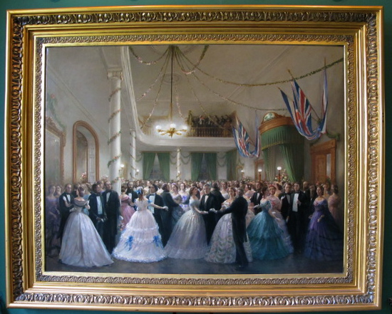
It rained all night and continued into the morning, but it was warm. We got a late start and went to Charlottetown, the biggest town in the province. We visited St Dunstan’s Basilica, an ornate cathedral w/ marble columns, and the Province House National Historic Site, where in 1864 delegates from the Maritimes and Canadian colonies got together to discuss forming a confederation. That explains the “Confederation” bridge, “Confederation” Trail and other “Confederation” places. The PEI legislature still meets in the Province House. We found a 2-for-1 lunch special at a tiny Japanese restaurant. By afternoon it had pretty much stopped raining, and we walked around the historic area. Reminded me a lot of New England but that’s probably because it was built in the same time period.

Potato Field
The next few days we drove and drove and drove, from one end of the island to the other. If you drive straight, it’s not too long, but we took the scenic routes, of course, and  so it really was a lot of driving. We drove a few more heritage roads. “What if we meet someone,” said David on a particularly narrow one. “There’s nowhere to pull over.” Shortly after, we came face to face with a two-horse-drawn piece of farm machinery. They stopped and pulled as far as possible into the woods while we inched by. The next road was hard to find, long and hilly. After a couple miles, it started ascending a steep hill. It got narrower and muddier and then looked like no one was really using it. “This looks like a trail,” said David. “We can’t go any farther.” Fortunately we were able to turn around and find another way out.

On this day we had a hard time finding a place to picnic. Each time we stopped  and started to walk over to a picnic table, we got swarmed by mosquitoes. So we kept driving and driving. Finally at 2:00 we found a beach park with no mosquitoes. We sat at a picnic table on the edge of a low red cliff with a perfect view of the ocean and a red sand beach.
I saw a large bird flying. “That’s a bald eagle!” I said. It alighted at a distance on top of the tallest tree. I got out the binocs and yes, it really was a bald eagle. As we ate I heard baying in the distance. I looked through the binoculars at some grey and brown rocks offshore. They were seals. Later we stopped at Lucy Maud Montgomery’s Birthplace. It was a small house on a corner. There were three or four other tourists milling about. A tour guide started talking to David and told him a month ago the place would have been mobbed. For diehard Anne of Green Gables fans, there are many sites to visit relating to the author, including a recreated village of Avonlea with people dressed up as characters in the book and acting out various scenes. All of these sites were closed for the season.

When all is said and done, we’re glad we’re here now. Then again, it’s only October 6. Next week in Nova Scotia, will we still feel the same?


Sunday, October 3, 2010

Seeing the Countryside by Car, Bike and Foot

To get to Prince Edward Island (PEI), we crossed the 8-mile long Confederation Bridge from New Brunswick. It was a blustery day, but there was less wind on the bridge than there had been on land. The impressive bridge is the longest in Canada (confederationbridge.com). 

Our campground was muddy and grassy and next to a busy highway. A noisy factory across the adjacent field never shut down. After two days we moved to another quieter campground with a more woodsy setting about 30 miles away. I had planned to go there anyway but decided to move there a day early.
The day after we arrived we drove along the southern central part of the island along the Northumberland Strait through pretty, pastoral countryside. We drove past cultivated fields of vivid yellow soybeans, corn ready to be harvested and bright green grass. Some fields had bales of hay waiting to be collected. Interspersed with farmland were swaths of woods with conifers and deciduous trees in full fall array, green meadows dappled with yellow, purple and white wildflowers and coastal marshes. 

We stopped at a few roadside markers and a light station. We drove on a narrow “heritage road” of red dirt with trees arching over it. We strolled through a pretty little seaside village, all closed up for the season. We walked across a bright green lawn at a small provincial park to peer down red cliffs at a red beach. Even the water is red near the shore. Everywhere on PEI the soil is red because of its high iron content. We learned some history at Port La Joye--Fort Amherst national historic site, which first was a French fort and then a British one. 
Closed for the season
When we got back to the campground, we got ready to ride our bikes on a spur of the Confederation Trail, which ran right beside our campground. The main trail is 175 miles long and runs almost the entire length of the island. We left at 4:15 pm. “I’ll be back at 6:15,” said David and took off. I had a pleasant ride on the mostly flat trail that used to be a railroad. It was much the same scenery we had seen from the car, but at a much slower pace. A picked an apple from a wild apple tree. The trees and their uneaten fruit are everywhere. I don’t think there are any large animals like deer on the island and not enough small animals to eat all the apples. I got back around 5:15, changed clothes, made some tea and worked on my journal. David wasn’t back at 6:20, so I went outside and hailed him on the walkie talkie. Surely he must be close. It was such a nice day and such a nice trail, he probably went a little farther than he had planned. He didn’t answer. He probably has it turned off, I thought. I went back inside and uploaded photos from the day. At 6:30, David still wasn’t back. I went outside and tried the walkie talkie again. Still no answer. Hmmm. That was strange. David is usually pretty prompt. But I wasn’t worried. What could go wrong? The trail was off the road, flat and practically deserted. He’ll be back any second. I went back in the trailer and worked on the blog. Then it was 7:00. David still wasn’t back. Something must be wrong. Could he have gotten lost? I tried the walkie talkie. No answer. I went to the truck (which I should have done earlier), got my phone, which was charging, and saw that there were 5 messages on it. Uh-oh. I immediately called David. 

He answered. “What’s wrong?” I asked. “Where are you?” “I had a flat tire. I can’t find my pump. I’ve been walking for five miles. I still have three miles to go.”  “Call me when you figure out where you are,” I said, “and I’ll come pick you up.” I got out the trail map and the highway map, started the truck and tried to figure out where the bike trail intersected a road. Then David called again and told me the number of a dirt road he was at. I found it on the map and went and picked him up. Usually when he gets a flat tire, it’s not a problem because he always carries a spare. This time, however, his bike pump had fallen out on a shelf in the trailer, so he wasn’t able to change his tire and had to walk in his cleated bike shoes. So now we keep the phones charged and with us.